

Frustrated with forecasts that turn out to have been wrong?
Maybe they weren’t, Captain…
After the freighter El Faro sank on October 1 2015 in Hurricane Joaquin, the NTSB noted that, among other factors contributing to the loss, that the Captain “had relied on outdated weather information from a commercial service”.
There are many great weather applications out there, but are you being served the best data? Where did the app GET the data from? Is the data old? We tend to just assume that what pops up on the app is the forecast, but we also seem surprised when “They Were Wrong”. The trick is to ask yourself some questions when you pull up a graphic or a forecast:
- Is it a reputable source?
- Is the data valid?
- Is the data timely?
Let’s look at a few and discuss how to verify whether your data is old, or from a questionable source.
Bottom line: NEVER TRUST A FORECAST WITHOUT A TIME STAMP
Here is a National Weather Service (NWS) marine point forecast from one of our favorite places, right where the Potomac meets the Chesapeake (who hasn’t experienced THOSE waves…?): https://marine.weather.gov/MapClick.php?lon=-76.34920&lat=37.99904#.XZSbbXt7nIU
These are easy. NWS forecasts are very up-to-date, since most weather data COMES from NWS. But to be sure it is timely, always look for this:
Last Update: 7:32 am EDT Oct 2, 2019
This is the date-time stamp. Seems obvious, but if it is old, refresh your browser to get the latest.
Here is a product from a non-NWS source used by ocean cruisers, Passage Weather.com:
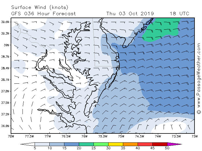
With graphics, before you even play around with it, scan it for date-time stamps.
- Is it a reputable source? Yes. This company has been around a while. Fellow mariners use it and you have heard good things…reputation matters.
- Is the data valid? Yes. How do you know? Top left. The data source is listed GFS. GFS is a National Weather Service model. Research to see if the GFS model has been forecasting well the past couple of days.
- Is the data timely? Maybe! Look at the time stamp. This is a forecast FOR Oct 3rd at 1800 Zulu* but it was MADE 36 hours ago. This might not be as timely as you want BUT AT LEAST YOU KNOW
Here is a product from a popular non-NWS source, Weather Underground:
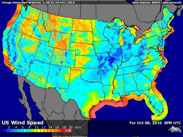
Again, before you even play around with it, scan it for date-time stamps.
- Is it a reputable source? Yes. This company has been around a while.
- Is the data valid? Yes. How do you know? Top right. The data source is listed as NDFD. Weather Underground uses NWS data. This data is from the National Digital Forecast Database. You may have to dig to see which model was used. “Search NWS NDFD Weather” for more.
- Is the data timely? Wait….no! Look top left, and bottom right. This is a forecast for Oct 8th that was produced on Oct 2nd. This may be useful as a long-range outlook, but if you pulled this up on Oct 8th, you would be using old data.
Coming soon: Captain Johnny’s weather and tide planning checklist!
*Zulu time is Greenwich Mean Time, the time in London. We use this so all of our clocks are hacked to the same time, no matter where we sail. Also written as GMT, UTC. Midnight Zulu time is around dinnertime in Occoquan. 1200 Zulu is breakfast, unless you drank too much last night, ya swab.
Good stuff! New boaters almost never check the weather… That is, until they get stuck out in a really bad storm! LOL!